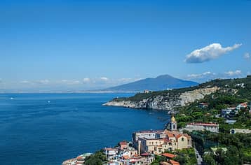
Massa Lubrense


Massa Lubrense has the largest municipal area on the Sorrentine Peninsula, stretching from the Sorrento cape to Punta Campanella and reaching as far as the coast along the Gulf of Salerno. It covers 20 square kilometers and encompasses 18 villages, including Sant’Agata sui due Golfi (often considered its own town).
The highlight of Massa Lubrense is without a doubt its beautiful landscapes, which include the Punta Campanella and Ieranto nature reserves, thick woods, rocky coastlines facing the island of Capri, the fishing village of Nerano, and views over the Bay of Naples and Salerno. This natural beauty is what makes Massa Lubrense one of the most picturesque spots in both the region of Campania and all of Italy.
Sights in Massa Lubrense
Sights in Massa Lubrense
The town limits of Massa Lubrense are quite spread out and cover the hills on the far western point of the Sorrentine Peninsula and the coastline along the Bay of Salerno.
This area has ancient roots, and legend holds that Ulysses encountered the mythological sirens between Punta Campanella and the Li Galli Islets. On Punta Campanella, an inscription was discovered in Osco, a pre-Italic language spoken before the era of the Romans, that indicates that there was once a commercial port here. Nearby, the remains of a temple dedicated to the goddess Minerva was also discovered.
Today, the town itself centers around the Chiesa di Santa Maria delle Grazie, just a few steps from the panoramic terrace overlooking the sea. The road sets off here to Marina della Lobra, a small fishing village and marina. Two other roads lead out of the center of town: one leads to the hills of Sant’Agata sui due Golfi and the other to Marciano, the Nerano beaches (Marina del Cantone), and the trails along Ieranto and Punta Campanella.
In Sant’Agata sui Due Golfi, stop to visit the Monastery of San Paolo (still inhabited by cloistered Benedictine nuns) in a spot known locally as “il deserto”. Here there is a sweeping view that extends from the Bay of Naples to the Amalfi Coast.
The Bay of Ieranto is another breathtaking sight, part of Italy's National Heritage Trust, which also offers guided hikes. The trail is open to the public.
The Bay of Ieranto
The Punta Campanella trail is easier and less steep than the Ieranto trail, which may not be suitable for everyone.
Punta Campanella
Should I Stay in Massa Lubrense?
Should I Stay in Massa Lubrense?
Massa Lubrense has the most beautiful landscapes and crystalline beaches on the Sorrentine Peninsula. That said, you must have a car or scooter to get around. There are buses that run between and the center of Massa and Sorrento and others that go to Sant’Agata and Nerano, but by far the easiest way to travel is with your own car. It takes about 15 minutes to drive between Massa Lubrense and Sorrento if you don't run into traffic.
There is a direct bus that passes through Sant'Agata to Positano and Amalfi (but not the center of Massa Lubrense). It's a bit more complicated to reach Pompeii, as you need to take the bus to Sorrento then the trail.
Dining in Massa Lubrense
Dining in Massa Lubrense
The area in and around Massa Lubrense has a high density of Michelin-starred and gourmet restaurants, so here are three suggestions depending upon your budget:
Don Alfonso 1890: historic restaurant with two Michelin stars, considered an institution of Italian cuisine.
Try: the chef's tasting menu
Location: Corso Sant’Agata 11, Sant’Agata sui Due Golfi
Tel: 081 8780026
Lo Stuzzichino: a traditional-style restaurant but elegant and refined
Try: gamberetti di Nassa di Crapolla (local shrimp)
Location: Via Deserto 1, Sant’Agata sui due Golfi
Tel: 081 5330010
Eughenes: homestyle restaurant in Termini
Try: spaghetti alla Nerano
Location: Via Roncato 9, Termini
Tel:081 8081989
Beaches in Massa Lubrense
Beaches in Massa Lubrense
Massa Lubrense is a "Blue Flag" area with crystalline beaches, especially near the Punta Campanella marine reserve. It's not always easy to reach the water, however, since most "beaches" are actually steep rocks that jut directly above the water. Here are the best-serviced beaches in the area:
Marina di Puolo: the closest beach to Sorrento set at the bottom of a narrow road at the cape of Sorrento, though there is also a less steep private road (the white gate just beyond the public road marked by the sign “Cala di Puolo”). Here the beaches are relatively accessible and suitable for children, but there are often various boats moored just offshore.
Capitan Cook: this beach club is set on the rocks and has an excellent restaurant. Park along the road and follow the path down for about two kilometers. There is a tuk-tuk shuttle service back up to the road from the beach.
Giardino Romantico: a beach club with two small beach areas, rocks, and a beautiful view of Capri.
Nerano: the Nerano beach is the largest in the area, a long stretch of pebbles lining clear water. There are a number of beach clubs and excellent restaurants along the water's edge.